and the distribution of digital products.
The HackerNoon Newsletter: Why Humanity’s Slow Space Progress Lags AI-and What That Means for Survival (5/15/2025)
1.1. Spatial Digital Twins (SDTs)
1.3. Different Components of SDTs
1.4. Scope of This Work and Contributions
2. Related Work and 2.1. Digital Twins and Variants
2.2. Spatial Digital Twin Case Studies
3. Building Blocks of Spatial Digital Twins and 3.1. Data Acquisition and Processing
3.2. Data Modeling, Storage and Management
3.3. Big Data Analytics System
3.4. Maps and GIS Based Middleware
3.5. Key Functional Components
4. Other Relevant Modern Technologies and 4.1. AI & ML
5. Challenges and Future Work, and 5.1. Multi-modal and Multi-resolution Data Acquisition
5.2. NLP for Spatial Queries and 5.3. Benchmarking the Databases and Big Data Platform for SDT
5.4. Automated Spatial Insights and 5.5. Multi-modal Analysis
5.6. Building Simulation Environment
5.7. Visualizing Complex and Diverse Interactions
5.8. Mitigating the Security and Privacy Concerns
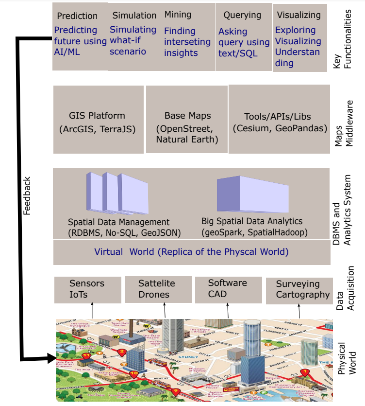
3. Building Blocks of Spatial Digital TwinsIn this section, we discuss enabling technologies for building a spatial digital twin (SDT). Figure 2 shows the block diagram of different layers of technologies and tools required for building an SDT. These layers are: i) data acquisition and processing technologies that include sensors, satellites, software systems etc. (Section 3.1); ii) spatial data modeling, storage and management systems (Section 3.2) and big spatial data analytics systems (Section 3.3); iii) GIS and map-based middlewares (Section 3.4); and iv) Key functionalities and/or operations (Section 3.5). It is important to note that there is no strict vertical or horizontal ordering of the spatial technologies as presented in Figure 2, i.e., vertical components of a layer can interact with each other, and similarly, a top layer component can interact with a bottom layer component skipping the middle layers.
3.1. Data Acquisition and ProcessingThe first stage in developing an SDT is acquiring and processing data about the physical environment. This includes remote sensing technologies (e.g., LiDAR, drones, satellite imagery etc.), positioning technologies (e.g., GPS), Internet of Things (IoT) sensors (e.g., air quality sensor, traffic sensor, GPS, cameras, etc.), software systems (e.g., CAD). The data captured from various data acquisition technologies must be processed to create a digital representation of the physical environment.
\ Building SDTs involves capturing a variety of real-world geo-spatial objects of different spatio-temporal dimensions. Examples include 2D or 3D layouts of buildings, spatio-temporal traces of moving objects, satellite images of the landscape, spatial networks (e.g., road networks), time series data of energy consumption of a building etc. The acquisition process of these data also varies significantly ranging from IoT-enabled sensor devices for capturing evolving data such as changing locations or energy consumption to software system such as CAD for generating detailed 3D layouts of buildings. As the acquisition technologies widely vary across data types and the required level of representation necessary for the spatial digital twins, it is challenging to make a uniform standard and quality of the captured data [32]. Consider an example of a GPS device, which is used to track and update the locations of a moving object. The frequency of updates of a GPS device decides the quality of the data that can be used in different applications, e.g., a low frequency update may be enough to derive the traffic conditions of the road, but may not be sufficient to analyze how eco-friendly the route is as the calculation of an eco-route depends on many detailed factors [33] such as acceleration/deceleration, instantaneous velocity, slope of the road, etc. Similarly, 3D modeling of objects can also be captured in many different resolutions, e.g., drones are used to capture 3D point clouds [34] which then pass through different pre-processing modeling steps [35] (i.e., segmentation, approximation, etc.) to generate 3D layouts of different buildings of the city. However, if we need the detailed indoor layout of a building we need to resort to software systems like CAD.
\ Existing research [36] highlights different technologies and different layers of spatial data such as terrain, buildings, infrastructure, and mobility for creating an urban digital twin. Recent research also identifies several data acquisition challenges including the large varieties of data, interoperability, and the requirements of huge computing power [11].
\
\
:::info Authors:
(1) Mohammed Eunus Ali, Department of Computer Science and Engineering, Bangladesh University of Engineering and Technology, ECE Building, Dhaka, 1000, Bangladesh;
(2) Muhammad Aamir Cheema, Faculty of Information Technology, Monash University, 20 Exhibition Walk, Clayton, 3164, VIC, Australia;
(3) Tanzima Hashem, Department of Computer Science and Engineering, Bangladesh University of Engineering and Technology, ECE Building, Dhaka, 1000, Bangladesh;
(4) Anwaar Ulhaq, School of Computing, Charles Sturt University, Port Macquarie, 2444, NSW, Australia;
(5) Muhammad Ali Babar, School of Computer and Mathematical Sciences, The University of Adelaide, Adelaide, 5005, SA, Australia.
:::
:::info This paper is available on arxiv under CC BY 4.0 DEED license.
:::
\